As we kick off 2025, the United States faces a significant challenge: an intense polar vortex and winter storm are expected to sweep across the country, bringing freezing temperatures, snow, and icy conditions to as many as 48 states. This severe weather event is forecasted to last from January 3rd to January 10th, with its impacts stretching from the Midwest to the South, and even affecting typically mild states like Texas and Florida.
What’s Happening?
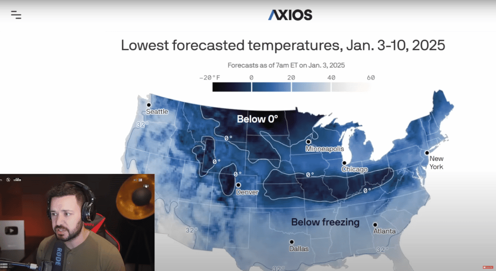
Meteorologists have issued warnings about a powerful Arctic outbreak tied to the polar vortex, a large area of low pressure and cold air swirling around the Earth’s poles. When the polar vortex weakens, frigid Arctic air flows southward, resulting in dangerously cold temperatures for regions unaccustomed to such weather. This phenomenon is set to usher in some of the coldest conditions in years, posing risks to daily life, travel, and infrastructure.
States on High Alert
From Kansas to Florida, millions of Americans are bracing for a historic cold snap. Key highlights include:
- Blizzard Warnings and Ice Storms: The central United States is already under blizzard warnings, with heavy snowfall expected to pile up in places like Kansas City and St. Louis, which may see their heaviest snowfalls in over a decade.
- Icy Roads and Blackouts: Ice accumulation is expected to wreak havoc, particularly in areas south of the heavy snow axis. Regions from Nebraska to West Virginia could experience widespread power outages due to downed trees and power lines.
- Deep Freeze in Southern States: Texas and Florida, not typically associated with harsh winter weather, are preparing for freezing or near-freezing temperatures starting January 8th. Even northern Florida counties are expected to experience significant wind chills.
A Recap of the Forecast
- Cold Wave Timing: The cold front began its march across the U.S. on January 3rd, and its effects will peak around January 8th-10th.
- Snow and Ice Totals:
- Kansas and Missouri are expected to receive over a foot of snow.
- The Mid-Atlantic region, particularly the Washington, D.C., and Baltimore areas, could see up to 8 inches of snow.
- Dangerous ice accumulation, which is often harder to navigate than snow, will be a major concern in areas to the south of the snow belt.
- Duration and Intensity: While the temperatures themselves may not break records, the prolonged duration of the cold spell—lasting well over a week—makes it a serious threat to everyday life and infrastructure.
Preparing for the Worst
To minimize the impacts of this severe weather:
- Avoid unnecessary travel to reduce accidents on icy roads.
- Stock up on essential supplies, including food, water, and heating fuel.
- Ensure your home is properly insulated to withstand freezing temperatures.
- Stay informed by following local weather updates and advisories.
Lessons from 2021
This isn’t the first time the U.S. has faced such a polar vortex. The 2021 winter storm that hit Texas caused rolling blackouts and widespread power outages, resulting in tragic loss of life and millions left without heat. Experts warn that lessons from that event should be applied now to avoid similar consequences.
Broader Implications
The impacts of this storm stretch beyond the immediate weather. Power grids across the affected states may struggle to meet demand during peak cold periods, potentially leading to outages. Additionally, the storm could disrupt travel, supply chains, and daily life for millions of Americans. Furthermore, natural gas prices are expected to spike due to increased heating demands.
A Winter to Remember
The polar vortex is a stark reminder that winter weather, while beautiful, can also be dangerous and unpredictable. As we prepare for what could be a historically impactful storm, it’s essential to heed warnings and take precautions to ensure safety.
Stay warm, stay safe, and stay tuned for updates as this story develops.